A Geopolitical Analysis of Kashmir Part 1: The Geographic Strategic Significance of Kashmir
In April 2025, sparks once again ignited between India and Pakistan in their struggle for Kashmir, with civilians caught in the crosshairs, and with the world holding its breath as two nuclear powers sparred. Through a three-part series on Kashmir, these articles will aim to provide an understanding of select key topics relevant to this complex and vast geopolitical region. These include covering the origins of the dispute, the importance of the Indus Water Treaty, and the investments by defence corporate businesses.This first article is intended to reflect historic and contextual perspectives influencing the political, military and social tensions in Kashmir today.
Kashmir evokes the majestic Himalayas, bordering both the Hindu Kush and Tibet Mountainous regions, and a picturesque landscape rivalling alpine Switzerland. These mountains, from Kashmir and neighbouring highlands, host many glaciers and melting snows, thus forming many important rivers such as the Jhelum, Chenab and Indus, which provide an essential life source to fertile lands both in Kashmir and further downstream.[1] Furthermore, these rivers are an essential source of freshwater to both India and Pakistan, contributing to supporting life on the subcontinent.[2] In addition, there are plenty of natural raw materials, from coal, magnesite, limestone, pinewood, as well as agricultural products. Both offer opportunities for the energy sector, such as through hydroelectric dams. Strategically, Kashmir has geographic, historic, and economic significance with a huge potential for influencing socio-economic growth for people of the Indian subcontinent. To no surprise, the Indus Valley Harappan and Mohenjo-Daro civilisations, among the earliest in the world, flourished along the Kashmiri rivers approximately in 3000 BCE.[3]
Topographically, Kashmir’s mountainous region offers impenetrable natural defences, presenting a daunting challenge to any invader attempting to cross. This factor influenced the first conquerors of India, who came during the summer across the Hindu Kush and the Himalayas when the passes were open, including Alexander the Great. With higher elevation, defenders have far greater visibility and range. Mountain passes are also vital for trade logistics, impact transportation, evacuation, and both supporting and assisting with the movement of armies. With modern-day artillery, bombarding key passes and routes causes significant military and logistical challenges. Hence, controlling such locations can either offer or deny supplies for mountain cities such as Muzafarrabad or Srinagar. Overcoming the geographical challenge is carefully studied in mountain warfare, and planning often emphasises that the priority is to master is topography and physicality of the terrain in which the battle must be waged, and then the enemy.[4]
Historically, several Kashmiri dynasties were founded, including the Karkota dynasty between 625-900 and the Shah Mir dynasty between 1339-1561. The first was influenced by Lalitaditya, originally a Hindu monarch, who engaged in military expeditions, unified and defended most of modern-day Kashmir and expanded Kashmiri influence. Besides conquests, Lalitaditya constructed Hindu and Buddhist temples and shrines across his journeys and developed watermills to help farmers with their irrigation systems.[5] During the Shah Mir dynasty, Islam was established and spread across Kashmir, and this influence continued to grow under subsequent Kashmiri Sultanates. Several of the Islamic rulers were oppressive against non-Kashmiri Muslims, whether Hindu or Buddhist, but others worked on building fair rule and rights between all faiths within Kashmir.[6] In the Indian subcontinent, several rulers – Ashoka’s Maurya Empire and Akbar’s Mughal Empire, strived to build secular frameworks to promote religious tolerance, good governance and cultural unison. Rulers who did not promote such religious tolerance planted the seeds of discord for longer-term challenges.
Furthermore, infrastructural development and urban planning affect the foundations of state administration and control. This creates the guiding blueprint for developing modern cities, where governance and state institutions can exert control over the region. Thus began a long series of events influencing Kashmiri society, becoming a majority Muslim state, with Hindu and Buddhist origins, influenced by the leadership’s priorities and vision of what Kashmir appeared and stood for.
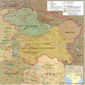
However, no invader over the millennial history of the Indian subcontinent created the divisions as the colonial powers who first arrived in 1608. Eventually, establishing the Radcliffe line dividing the British Raj and the fueling of religious tensions is a bloody legacy of the British rule era. When the people revolted against foreign rule, tensions erupted due to the Partition in 1947, marking the independence from Britain and the creation of the new states of India and Pakistan. During Partition, one of the largest mass displacements of people took place, with approximately 12-15 million people crossing over on both sides from India and Pakistan. It was a period marked by violent clashes resulting in hundreds of thousands of casualties.[7] In Kashmir, Maharaja Hari Singh, a Hindu ruler, intended to rule an independent princely state, like Hyderabad, in India and Kalat, in Pakistan. However, militias and soldiers disguised as Pashtun tribesmen, invaded Kashmir[8]and the Maharaj sought aid and protection from India and ultimately agreed to join the Dominion of India (now the Union of India)..[9] The first Indo-Pakistan War in 1947 occurred, where neither side was able to claim full territorial control of the state, ending in a cease fire, overseen by a UN subcommittee. Eventually, despite two more wars, a de-facto border evolved into the Line of Control (LOC) in the 1972 Silma Agreement,.[10] Today the region is termed as Jammu and Kashmir and Pakistan occupied Kashmir (POK) by India, and Azad Jammu and Kashmir (AJK) and Indian administered Kashmir by Pakistan.
For people living in Kashmir today or for people living elsewhere, reading the news about the instability and tension, the background to why the conflict is still ongoing may be lost or confusing. Much has been written about this hotbed of geopolitical theatre, and to find any hope of peace, it will be essential to ground strategy in essential factors originating from the physical geography, historical context, and colonial influence, which have contributed to the conflict. The struggle for the strategic control of the mountain ranges for defensive purposes, given the rich resources and population, can influence the direction of what happens to their home.[11]
Reference:
[1] Golam Rasul, “The Role of the Himalayan Mountain Systems in Food Security and Agricultural Sustainability in South Asia”, International Journal of Rural Management, (13 June 2011), URL: https://doi.org/10.1177/097300521100600105
[2] David Gilmartin, Blood and Water: The Indus River Basin in Modern History, (University of California Press, 2015) URL: https://www.jstor.org/stable/10.1525/j.ctt14jxvds
[3] Thomas R. Trautmann, India Brief History of a Civilization, (Second Edition, Oxford University Press, January 2015)
[4] Headquarters, Department of the Army, “Mountain Warfare and Cold Weather Operations”, Army Techniques Publication, Washington D.C. (29 April 2016)
[5] Upinder Singh, A History of Ancient and Early Medieval India, (Pearson Education 2008)
[6] Mohibbul Hasan, Kashmir Under the Sultans, (Aakar Books, 2005)
[7] CNN World, “Faith, Fury and fear: the story behind one of history’s greatest mass migrations”, Monica Sarkar, 15 August 2018, URL: https://edition.cnn.com/2017/08/08/asia/india-pakistan-independence-timeline
[8] Times of India, ‘Today in History: Maharaja Hari Singh signed instrument of accession making Kashmir part of India’ 26 October 2023 URL: https://timesofindia.indiatimes.com/india/today-in-history-maharaja-hari-singh-signed-instrument-of-accession-making-kashmir-part-of-india/articleshow/104727961.cms
[9]European Foundation for South Asian Studies, ‘22 October 1947: The Darkest day in the history of Jammu & Kashmir’ 16 October 2020, URL: https://www.efsas.org/commentaries/22-october-1947-the-darkest-day-in-the-history-of-jammu-and-kashmir/?ref=drishtikone.com
[10] Council of Foreign Relations, Global Conflict Tracker: Conflict between India and Pakistan, Center for Preventive Action, 12 May 2020, URL: https://www.cfr.org/global-conflict-tracker/conflict/conflict-between-india-and-pakistan
[11] Central Intelligence Agency, “Map of Kashmir region created by the US Central Intelligence Agency” 14 November 2019, URL: https://commons.wikimedia.org/w/index.php?curid=83941334